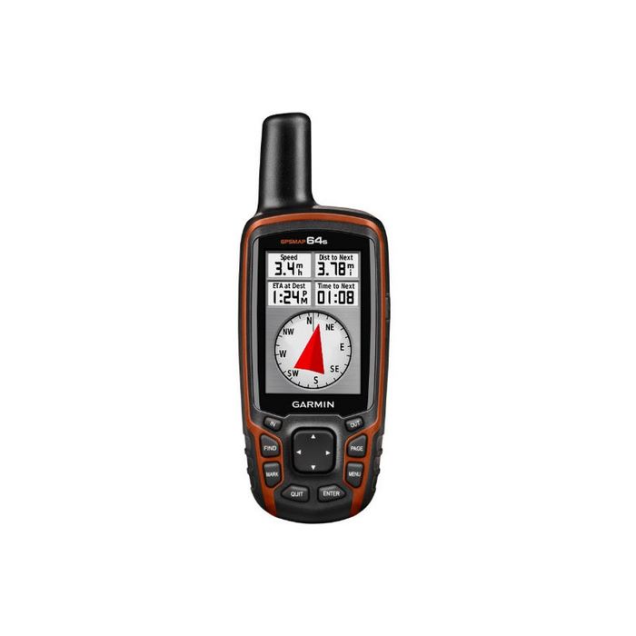
Garmin Rino 650
Garmin Rino 650
Hand Held Two Way Radio / GPS Tracker
Country of origin:
Secure Payment

Garmin Rino 650 combines a 5 watt UHF radio with a 2.6″ glove-friendly colour touchscreen GPS packed full of powerful features like a barometric altimeter, 3-axis compass to Pinpoint Your Position.
With its high-sensitivity GPS receiver and HotFix, Rino 650 quickly finds your position and maintains it – even in heavy cover. Plus, a built-in barometric altimeter and 3-axis compass make it easy to get your bearings.
The device comes with a worldwide basemap, so you can navigate anywhere with ease. Adding more maps is easy with Garmin’s wide array of detailed topographic, marine and road maps.
The Garmin Rino 650 lets you load Australian & New Zealand maps, The device also supports , that lets you download satellite images to your device and integrate them with your maps. In addition, Rino 650 is compatible with Custom Maps, free software that transforms paper and electronic maps into downloadable maps for your device.
Find Your Friends
Rino 650’s unique Position Reporting capability lets you send your exact location to other Rino users so they can see it on their map page. Plus, improved audio performance means it’s easy to communicate with any other conventional UHF radio in the area. It can be useful in an emergency, or just a handy way to keep tabs on your hunting party, hiking partner, family or friends.
Stay in Touch
With plenty of transmit power, Garmin Rino 650 also lets you send unit-to-unit text messages to other Rino users in your area – it’s ideal for loud or windy conditions, or just when you don’t want to disturb the wildlife. It also lets you share your waypoints, tracks, routes and geocaches wirelessly with other compatible Garmin handheld devices.
TOPO Maps:
Garmin Rino 650 comes with Worldwide Base-map. However, to get the best out of your Rino 650, choose between Garmin Topo Lite Maps or Full Topo Maps. Both the maps have same track information. The main difference is that Topo Lite Maps show 40m contour lines and Full Topo shows 10m contour lines
- Physical dimensions 2.4″ x 7.5″ x 1.8″ (6.0 x 19.0 x 4.5 cm)
- Physical dimensions 2.4″ x 7.5″ x 1.8″ (6.0 x 19.0 x 4.5 cm)
- Weight 11.3 oz (320 g) with battery pack
- Water rating IPX7Battery removable, rechargeable lithium-ion battery pack
- Display type 2.6″ transflective, 65K color TFT
- Display size 1.43″ x 2.15″ (3.6 x 5.5 cm); 2.6″ diag (6.6 cm)
- Display resolution 160 x 240 pixels
- Battery life 14 hours (up to 18 hours with optional AA battery pack)
- Memory/History 1.7 GB
- Transmit power 0.5 watts FRS,
- High-sensitivity receiver Interface high-speed USB and NMEA 0183 compatible
- Maps & Memory Ability to add maps Base
- map Storage and Power Capacity microSD™ card (not included)
- Waypoints/favorites/locations2000Routes200Tracklog 10,000 points,200 saved tracks
- Sensors Barometric altimeter Compass Yes (tilt-compensated 3-axis)Outdoor Recreation Features
- Area calculation Automatic routing (turn by turn routing on roads)
- Geocaching-friendly Hunt/fish calendar Sun and moon information Picture viewer Two-way Radio
- Vibration alert – yes / NO
- AA weather radio – yes